Short answer
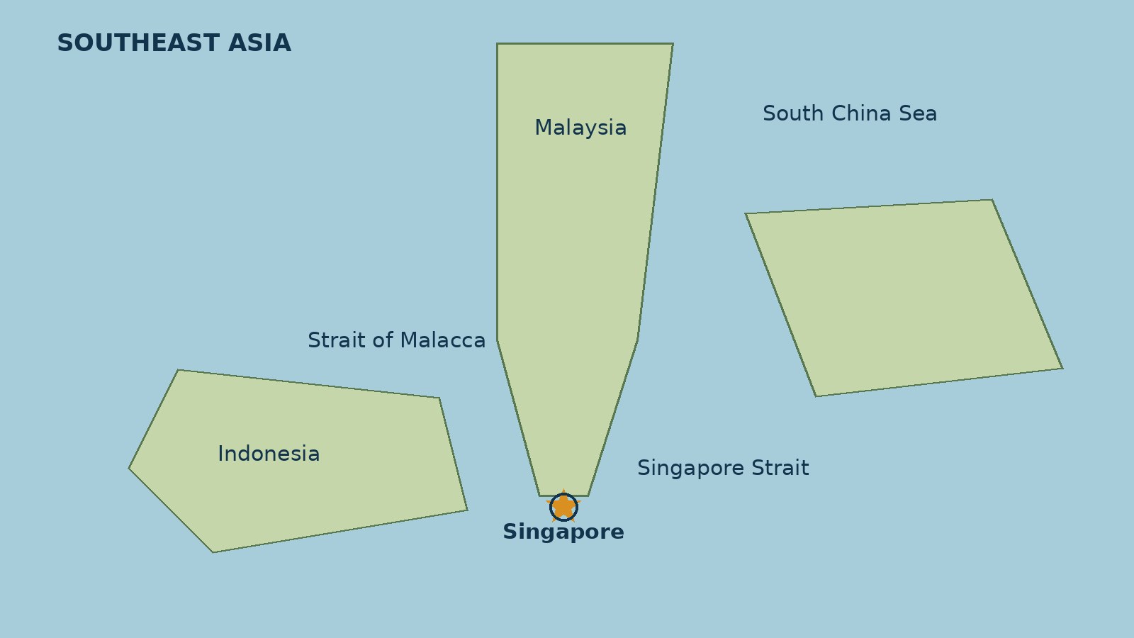
- Yes, Singapore is in Asia. More precisely, Singapore is an island city-state in Southeast Asia, off the southern tip of the Malay Peninsula, about 137 kilometers (85 miles) north of the equator. It sits between Malaysia to the north and Indonesia to the south, with the Strait of Malacca to the west and the South China Sea to the east. The United Nations geoscheme lists Singapore under South-eastern Asia, within the continental region of Asia, and Encyclopaedia Britannica describes Singapore as a city-state at the southern tip of the Malay Peninsula and the largest port in Southeast Asia. That short answer settles the question, but it leaves out the reason the question is asked so often. Singapore is small, famously orderly and global in outlook, English speaking in public life, and home to a population that is mostly of Chinese descent. Those features can make it feel placeless, or make readers wonder whether it belongs to China, to Malaysia, to some island region of its own, or to no continent at all. None of those guesses is right. Singapore is a sovereign Asian country, and this article shows where it sits, who its neighbors are, why the confusion arises, and what the words continent, region, and subregion actually mean when they are applied to Singapore.
Why a simple question deserves a careful answer
“Singapore is in Asia” sounds like a statement that should need no article. It does, for the same reason the parallel question about Greece needed one: the words people use for place are doing more than one job at once. Asia is a continent, Southeast Asia is a region inside that continent, and maritime Southeast Asia is a smaller subregion inside that region. Singapore also belongs to political and economic groupings, such as the Association of Southeast Asian Nations (ASEAN), that are regional but are not continents. Mixing those layers up is easy, and once they are mixed up, a small island country can seem to float free of every map.
There is a second reason. Many readers meet Singapore first as a brand rather than as a place: an airport consistently ranked among the best in the world, a port, a financial center, a stopover city, or a skyline photograph. A place that is famous for being connected to everywhere can start to feel as if it belongs nowhere in particular. The geography corrects that impression. Singapore has a fixed address on the map, fixed neighbors, fixed straits on either side, and a fixed history as a trading settlement at the southern end of a peninsula. This article pins that address down.
A third reason is the phrase itself. The banked search phrase is a statement, “singapore is in asia,” not a question. A literal-phrase search returns general reference pages about Singapore, led by encyclopedia entries, rather than a set of question-form explainers competing to answer it. The dominant intent is therefore informational confirmation: the reader wants a reliable yes, a precise location, and an explanation of the labels. This article is written for that reader. It keeps the statement headline, because the search results do not support recasting it as a question, and it answers the underlying question in the first paragraph.
The geographic answer: where Singapore sits
Start with the continent, then narrow down. Singapore is in Asia. Within Asia, it is in Southeast Asia. Within Southeast Asia, it is in maritime Southeast Asia, the island and peninsula part of the region, as distinct from mainland Southeast Asia, the part that includes Thailand, Vietnam, Cambodia, Laos, and Myanmar on the Asian mainland. That three-step narrowing is the whole answer in miniature, and everything else in this article is detail and evidence for it.
Britannica puts Singapore at the southern tip of the Malay Peninsula, about 85 miles (137 kilometers) north of the equator. It consists of Singapore Island, described as diamond shaped, plus some 60 small islets. The main island occupies almost all of the combined area. The main island is separated from peninsular Malaysia to the north by the Johor Strait, a narrow channel crossed by a road and rail causeway more than half a mile long. The southern limits of the state run through the Singapore Strait, where outliers of the Riau-Lingga Archipelago, which forms part of Indonesia, extend to within 10 miles of the main island.
That description gives the reader four anchors: a peninsula, a northern neighbor, a southern neighbor, and two straits. The Malay Peninsula is the long finger of land that runs south from mainland Asia through Thailand and Malaysia. Singapore sits just off its southern tip, like a period at the end of a sentence. Malaysia is the country on the other side of the northern strait. Indonesia is the country whose islands lie across the southern strait. The Strait of Malacca, to the west, connects the Indian Ocean to the South China Sea, and Singapore owes much of its history to its position at the southern end of that passage.
The table below keeps the layers of place separate, because most confusion about Singapore comes from collapsing them into one word.
| Layer of place | Singapore’s position | What it means |
|---|---|---|
| Continent | Asia | The large landmass and its nearby islands, as classified by standard atlases and the UN geoscheme |
| Region | Southeast Asia | The southeastern part of Asia, covering the mainland states and the archipelagos to the south and east |
| Subregion | Maritime Southeast Asia, in the UN term South-eastern Asia | The island and peninsula portion of Southeast Asia, including Singapore, Malaysia, Indonesia, Brunei, the Philippines, and Timor-Leste |
| Political grouping | ASEAN | A regional association of Southeast Asian states, founded in 1967, of which Singapore was a founding member |
| Country type | Island city-state | A sovereign country whose territory is essentially one city and its surrounding islands |
None of those rows contradicts any other. Singapore can be Asian, Southeast Asian, maritime Southeast Asian, an ASEAN member, and a city-state all at once, because each row answers a different question.
A map in words: neighbors, straits, and seas
To picture Singapore, start with the peninsula and work outward. The Malay Peninsula runs south from mainland Asia. At its southern end, a narrow strip of water, the Straits of Johor, separates the peninsula from Singapore Island. On the far side of that water lies the Malaysian state of Johor. Two crossings link Singapore to Malaysia: the Woodlands crossing in the north and the Tuas crossing in the west. Those crossings matter, because they show that Singapore is not remote. It is a short drive from another country, and thousands of people cross that border for work and family every day.
Turn west from Singapore and the water widens into the Strait of Malacca, one of the busiest shipping passages in the world. It runs between the Malay Peninsula and the Indonesian island of Sumatra, and it connects the Indian Ocean in the west to the South China Sea in the east. Singapore sits at the southern, South China Sea end of that strait, which is why ships passing between Europe, the Middle East, and East Asia have called there for two centuries. Britannica notes that Singapore dominates the Strait of Malacca in this geographic sense, and that it is the largest port in Southeast Asia and one of the busiest in the world.
Turn south and the water is the Singapore Strait. Across it lie the Riau Islands of Indonesia, the nearest of which are close enough to see from Singapore’s southern coast on a clear day. Turn east and the water is the South China Sea, the large sea that borders Vietnam, the Philippines, and southern China. Singapore does not border China, and it does not sit in the South China Sea in the sense of being surrounded by it. It sits at its southwestern edge, at the point where that sea meets the Strait of Malacca.
Continent, region, and subregion: what each word means
Much of the confusion about Singapore comes from treating “Asia,” “Southeast Asia,” and “the Far East” as if they were interchangeable, or as if a country had to pick one. They are nested categories, and a country belongs to all of them at once at different levels of detail.
A continent is the largest geographic grouping. Asia is the largest continent, stretching from Turkey in the west to Japan in the east, and from Siberia in the north to Indonesia in the south. Standard classification puts Singapore in Asia without dispute. No major atlas, encyclopedia, or statistical system places Singapore on any other continent, and no serious argument exists for placing it in Oceania, Africa, or any other continent. The question “is Singapore in Asia” therefore has an unusually firm answer for a geography question: yes, in every standard system.
A region is a smaller division inside a continent. Southeast Asia is the region that covers the countries south of China and east of India, including both mainland and island states. It is sometimes divided into mainland Southeast Asia and maritime Southeast Asia. Mainland Southeast Asia is the part attached to the Asian mainland. Maritime Southeast Asia is the part made up of peninsulas and archipelagos surrounded by sea, including Malaysia, Singapore, Indonesia, Brunei, the Philippines, and Timor-Leste. Singapore belongs to the maritime part, because it is an island country off a peninsula, not a mainland state.
A subregion, in the UN sense, is a statistical grouping used to organize data. The UN Statistics Division geoscheme, known as M49, lists Singapore under South-eastern Asia, with the code 035, inside the continental region Asia, code 142. The other members of that subregion are Brunei, Cambodia, Indonesia, Laos, Malaysia, Myanmar, the Philippines, Thailand, Timor-Leste, and Vietnam. That list is useful because it shows, in one place, exactly which countries the UN counts as Singapore’s regional peers. It is a statistical convenience, not a law of nature, but it agrees with the standard atlases, and it is the grouping used in most international statistics.
How big is Singapore, and what is it made of?
Singapore is small by country standards, and its smallness is part of why readers ask where it is. Britannica gives a total area of 736 square kilometers (284 square miles), with a population estimated at about 6,221,000 in 2026. Other reference sources give slightly different area figures, because Singapore has grown through land reclamation, the process of creating new land from the sea, and because different years and different measurement methods produce different totals. The honest statement is therefore a rounded one: Singapore covers roughly seven hundred and forty square kilometers, and the exact figure depends on the year and the source. What does not change is the order of magnitude. Singapore is a compact country, smaller than many cities, and almost entirely urban.
The country is made up of one main island and dozens of smaller islands and islets. Britannica counts some 60 small islets besides the main island. The main island is about 50 kilometers from east to west and about 27 kilometers from north to south, which means it can be crossed by car in well under an hour in light traffic. The larger offshore islands include Sentosa, just off the southern coast, Pulau Ubin in the northeast, and Pulau Tekong, which is used for military training. Most of the smaller islands are uninhabited or used for industry, defense, or nature conservation, and most Singaporeans live on the main island.
The land itself is low. Britannica notes that nearly two-thirds of the main island lies less than 15 meters (about 50 feet) above sea level. The highest point, Timah Hill, also called Bukit Timah Hill, is only about 162 meters (531 feet) high, according to Britannica, and it sits in a block of rugged terrain in the center of the island. Other sources give slightly different heights for the same hill, around 163 to 166 meters, depending on the survey and the point measured, so the precise figure should be treated as approximate. The point that matters for this article is not the exact number of meters. It is that Singapore has no mountains in any serious sense, no inland wilderness of the kind found in larger countries, and no natural lakes of significant size. It is a low, flat to gently rolling island, almost entirely built up, with its population concentrated along the southern coast and in planned towns across the island.
What “city-state” means, and why it confuses readers
Singapore is often called a city-state, and that term is accurate, but it needs unpacking, because it is the source of several misunderstandings.
A city-state is a sovereign country that consists essentially of a single city and its surrounding territory. In Singapore’s case, the city and the country have the same name, the capital is Singapore, and the built-up area covers most of the main island. There is no separate countryside of farms and villages of the kind that makes up most of other countries, and there is no second major city to contrast with the capital. Britannica records that the country is 100 percent urban in its 2024 urban-rural figures, and that about four-fifths of the population lives in high-rise flats built by the Housing and Development Board, in housing estates and new towns scattered across the island.
Another confusion is whether Singapore is part of China. It is not. Most Singaporeans are of Chinese descent, and Mandarin Chinese is one of Singapore’s four official languages, alongside English, Malay, and Tamil, with Malay as the national language. But ethnicity is not citizenship, and language is not sovereignty. Singapore’s population also includes substantial Malay and Indian communities, and its political history, legal system, and foreign policy are its own. A country is not part of another country because many of its people share an ancestry with people in that other country, any more than the United States is part of England because many Americans speak English.
The political answer: independence and ASEAN
Geography alone answers the question, but the political answer strengthens it, because it shows that Singapore’s Asian position is not just a matter of latitude. It is a matter of membership and history.
Singapore became an independent state on August 9, 1965, after seceding from Malaysia, according to Britannica. Before that, it had been a British colony, and before that a trading settlement founded in its modern form in 1819. The sequence matters, because it shows that Singapore’s independence was not granted by a distant power as a favor. It was the result of a political separation from a neighboring Southeast Asian federation, and it left Singapore as a small, newly independent Southeast Asian state with no natural resources, no hinterland, and a strategic port as its main asset.
Two years after independence, Singapore became a founding member of ASEAN. The Ministry of Foreign Affairs of Singapore states that Singapore was one of the founding members of ASEAN when it was formed on August 8, 1967, along with Indonesia, Malaysia, the Philippines, and Thailand. ASEAN is the Association of Southeast Asian Nations, and its name states its region plainly. A country does not become a founding member of a Southeast Asian association by accident. Singapore helped found ASEAN because it is Southeast Asian, because its neighbors are Southeast Asian, and because its security and prosperity depended on cooperation with those neighbors.
Singapore is also a member of the Commonwealth, the association of states most of which were formerly part of the British Empire. Commonwealth membership is a historical and political link, not a geographic classification, and it does not place Singapore in Europe or anywhere else. It reflects the colonial past that Singapore shares with Malaysia, India, Australia, and many other states, and it is listed here only to prevent a reader from mistaking it for a geographic claim. Geography puts Singapore in Asia. History explains why it also belongs to a Commonwealth whose members span every continent.
The practical markers of sovereignty are worth stating, because they are the everyday proof of the geographic answer. Singapore’s currency is the Singapore dollar. Its time zone is UTC plus 8 hours, the same as much of East and Southeast Asia, including China, Malaysia, and the Philippines, and 8 hours ahead of Coordinated Universal Time. Its internet domain is .sg. Its telephone calling code is +65. Its official languages are English, Mandarin Chinese, Malay, and Tamil. None of those facts alone proves a continent, but together they describe a normal Asian sovereign state, not a dependency, not a city inside another country, and not a territory floating between regions.
Why people ask: the real sources of confusion
Several genuine features of Singapore make the question feel reasonable, and each one has a clear answer.
First, Singapore’s population and language profile can mislead. English is the main language of administration, commerce, and education, according to Britannica, and that can make Singapore feel familiar to an English-speaking reader in a way that other Southeast Asian countries may not. Familiarity is not geography. English is an official language in many Asian countries, including India, Pakistan, and the Philippines, because of colonial history, and its use in Singapore reflects the same history. It does not make Singapore European or American.
Second, the ethnic composition can mislead in the other direction. About three quarters of Singaporeans are of Chinese ethnicity, according to Britannica’s summary figures, with most of the rest Malays and Indians. A reader who equates ethnicity with country may therefore guess China. That guess confuses ancestry with citizenship, as noted above, and it ignores the Malay and Indian communities who are equally Singaporean, the Malay national language, and the fact that Singapore’s foreign policy is independent of Beijing. Singapore trades heavily with China, as it trades heavily with many countries, but trade is not membership.
Third, Singapore’s closeness to the equator and its island character can suggest Oceania. Oceania is the region that includes Australia, New Zealand, Papua New Guinea, and the Pacific island states. Singapore is not in Oceania. It is separated from Oceania by Indonesia, a large archipelago that stretches between Southeast Asia and the Pacific, and it is classified by the UN, by atlases, and by its own regional memberships as Asian. Island character alone does not make a place Oceanian, any more than Britain’s island character makes it non-European.
Edge cases that prove the rule: Malaysia, Indonesia, and the region
The best way to test a geographic claim is to look at the neighbors, because a country’s region should make sense alongside theirs.
Malaysia is Singapore’s northern neighbor, across the Straits of Johor. Malaysia is unambiguously in Southeast Asia, and no one asks whether Malaysia is in Asia. Singapore sits off Malaysia’s southern tip, in the same region, separated by a narrow strait. It would be strange for Malaysia to be in Southeast Asia and for the island just off its southern coast, in the same seas, to be anywhere else.
Indonesia is Singapore’s southern neighbor, across the Singapore Strait. Indonesia is the largest country in Southeast Asia, an archipelago of thousands of islands stretching from Sumatra in the west to Papua in the east. Singapore sits at Indonesia’s northwestern edge, near the Riau Islands. Again, the regional fit is exact. Singapore is part of the same archipelagic world as Indonesia, Malaysia, and Brunei, the maritime Southeast Asian states that share seas, straits, and trading history.
What the answer means in practice
For most readers, the question matters for travel, money, and paperwork. Singapore is reached as a Southeast Asian destination, with flights arriving at Changi Airport and onward connections across the region, and with road crossings to Malaysia across the causeways. Singapore uses the Singapore dollar, abbreviated SGD, not the Malaysian ringgit, the Indonesian rupiah, or the Chinese yuan. Singapore is 8 hours ahead of Coordinated Universal Time, so a caller from London at noon reaches Singapore in the early evening. English is widely used, and a visitor who speaks only English can manage well, but Malay is the national language, and the school system teaches English alongside a mother tongue language. As a sovereign state, Singapore makes its own laws, conducts its own foreign policy, and takes part in international bodies as itself. If Singapore left ASEAN tomorrow, it would still be in Southeast Asia, just as a country that leaves a club does not move on the map.
The history behind the answer in brief
Singapore’s location explains its history, and its history confirms its location. The island was long known as Temasek, a trading settlement, and later as Singapura, before its modern era began in 1819, when Stamford Raffles established Singapore as a trading post of the British East India Company. Britannica notes that it became part of the Straits Settlements and the center of British colonial activity in Southeast Asia, and that during the Second World War the Japanese occupied the island from 1942 to 1945. In 1946 it became a crown colony. It achieved full internal self-government in 1959, became part of Malaysia in 1963, and gained independence in 1965.
Frequently asked questions
Is Singapore in Asia?
Yes. Singapore is an island city-state in Southeast Asia, off the southern tip of the Malay Peninsula, between Malaysia and Indonesia. The UN geoscheme lists Singapore under South-eastern Asia, within Asia.
Is Singapore in Southeast Asia or East Asia?
Southeast Asia. East Asia, in the UN geoscheme, covers China, Japan, Korea, Mongolia, and their neighbors. Singapore is in the South-eastern Asia subregion, alongside Malaysia, Indonesia, Thailand, Vietnam, the Philippines, Brunei, Cambodia, Laos, Myanmar, and Timor-Leste.
Is Singapore a country or a city?
Both, in the city-state sense. Singapore is a sovereign country whose territory is essentially one city and its surrounding islands. It has its own government, currency, passport, and foreign policy, so for geographic and political purposes it counts as a country, not as a city inside another country.
Is Singapore part of Malaysia?
No, not anymore. Singapore was part of the Federation of Malaysia from 1963 until it became an independent state on August 9, 1965. Today Singapore and Malaysia are separate sovereign countries, joined by causeways across the Straits of Johor.
Is Singapore part of China?
No. Most Singaporeans are of Chinese descent, and Mandarin Chinese is an official language, but Singapore is an independent sovereign state with its own government and foreign policy. Ethnicity and language do not make one country part of another.
Is Singapore in Oceania or Australia?
No. Singapore is in Asia, not Oceania. It is separated from Oceania by Indonesia, and it is classified in Asia by the UN geoscheme, by atlases, and by its ASEAN membership. Island character alone does not place a country in Oceania.
What continent is Singapore on?
Asia. More specifically, Singapore is in Southeast Asia, in maritime Southeast Asia, at the southern tip of the Malay Peninsula, about 137 kilometers north of the equator.
Where is Singapore on the map?
Look at the southern tip of the Malay Peninsula, in Southeast Asia. Singapore is the small island country just off that tip, with Malaysia to the north across the Straits of Johor, Indonesia to the south across the Singapore Strait, the Strait of Malacca to the west, and the South China Sea to the east.
What are Singapore’s neighboring countries?
Malaysia to the north, across the Straits of Johor, and Indonesia to the south, across the Singapore Strait, are the two neighboring countries. Singapore has no land border in the usual sense, because it is an island country, but it is linked to Malaysia by causeways, and Indonesian islands lie close across the southern strait.
Is Singapore in the Southern Hemisphere?
No. Singapore is just north of the equator, in the northern hemisphere, at about 1 degree 17 minutes north latitude. It is one of the closest sovereign countries to the equator in Asia.
Sources & references
- Encyclopaedia Britannica, "Singapore" place page, opened October 24, 2026. City-state at the southern tip of the Malay Peninsula, about 85 miles (137 kilometers) north of the equator; main island plus some 60 small islets; Johor Strait and causeway to the north; Singapore Strait and Riau-Lingga Archipelago to the south; largest port in Southeast Asia and one of the busiest in the world; Strait of Malacca connecting the Indian Ocean to the South China Sea; Federation of Malaysia in 1963 and independent state on August 9, 1965; total area 736 square kilometers; population 2026 estimate 6,221,000; official languages English, Mandarin Chinese, Malay, and Tamil; unitary parliamentary republic; equatorial monsoon climate and temperature figures; nearly two-thirds of the main island below 15 meters; Timah Hill about 162 meters; 100 percent urban in 2024 figures and about four-fifths of the population in Housing and Development Board flats.
- Encyclopaedia Britannica, "Singapore summary," consulted via search result October 24, 2026. Island country in Southeast Asia, off the southern tip of the Malay Peninsula; area 736 square kilometers; population 2026 estimate 6,221,000; Chinese, Malay, and Indian population composition; largest port and petroleum refining and manufacturing notes; independence in 1965 after joining Malaysia in 1963.
- United Nations geoscheme, as shown by the UN Population Division data portal and the UN geoscheme country list, consulted via search results October 24, 2026. Singapore listed under South-eastern Asia, code 035, within Asia, code 142, alongside Brunei, Cambodia, Indonesia, Laos, Malaysia, Myanmar, the Philippines, Thailand, Timor-Leste, and Vietnam.
- Singapore Ministry of Foreign Affairs, "Association of Southeast Asian Nations (ASEAN)" page, consulted via search result October 24, 2026. Singapore was one of the founding members of ASEAN when it was formed on August 8, 1967, along with Indonesia, Malaysia, the Philippines, and Thailand.
- Geography of Singapore reference summary, consulted via search result October 24, 2026. Continent Asia, region Southeast Asia, coordinates 1 degree 17 minutes north and 103 degrees 50 minutes east, mainland about 50 kilometers east to west and 27 kilometers north to south, coastline 193 kilometers, highest point Bukit Timah Hill about 164 meters in that summary, used here only to note the small variation in height figures between sources.
- Note on a source not used: the CIA World Factbook country page for Singapore, attempted October 24, 2026, now displays a farewell notice stating that the Factbook has sunset. No Factbook figures are used in this draft, and QA should not restore Factbook figures without a live, checkable Factbook page.


